• Home
    • About BYCAM
  • About us
    • Staff Profile
  • ASSESSMENTS
    • Fisheries
    • Governance & Socio-economics
  • MITIGATION
  • DATA MAPPING
  • FINAL FRAMEWORK
  • DOWNLOADS
    • Reports
    • Publications
  • GALLERY
    • Images
    • Videos
  • Contact

Data mapping

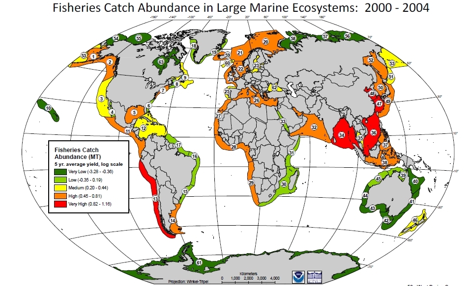
An interactive online spatial database (ArcGIS online has been developed to extrapolate the project findings to the entire WIO region and give a regional assessment of bycatch. It incorporate baseline data available in the WIO from previous surveys carried out by SWIOFP and National Fisheries datasets (e.g. CAS data) and data collected during the project duration. This fully query-able database will be used to identify areas of importance and hotspots, both in terms of risk of overfishing and population declines, and also areas where more research is required (research gaps). 
​

The data focuses into
  • fishing grounds and data for fisheries effort, gear type composition, species catch, composition and volume, along with socio-economic values been mapped. These to be will be complimented with
  • Large-scale habitat mapping using remote sensing data (SST, Primary Production, derived bathymetry etc.) sourced from the Natural Environment Research Council Earth Observation Data Acquisition and Analysis Service (NEODAAS). Fisheries data will be compiled for case study regions and extrapolated to other WIO fishing grounds based on available fisheries data for these other regions.
  • Archived datasets (from SWIOFP surveys and National fisheries Datasets) will be included in the analyses. Different thematic maps will be produced (e.g. fishing grounds, migratory patterns, survey routes, fisheries effort, gear usage, bycatch species etc.) including web/online atlas maps. 


Available datasets and maps
  1. Artisanal Fisheries Catch both reported and unreported including Sharks and Rays
  2. Industrial Fisheries Catch both reported and unreported including sharks and Rays
  3. Subsistence Fisheries Catch both reported and unreported including sharks and Rays
  4. Recreational Fisheries Catch for EEZs
  • Country Level Datasets
  1. Kenya Artisanal Fisheries data
  2. Mozambique Artisanal Fisheries Data
Other Fisheries Databases
  1. Statbase
  2. Chimaera
  3. Sea Around Us
Picture
Powered by Create your own unique website with customizable templates.
  • Home
    • About BYCAM
  • About us
    • Staff Profile
  • ASSESSMENTS
    • Fisheries
    • Governance & Socio-economics
  • MITIGATION
  • DATA MAPPING
  • FINAL FRAMEWORK
  • DOWNLOADS
    • Reports
    • Publications
  • GALLERY
    • Images
    • Videos
  • Contact